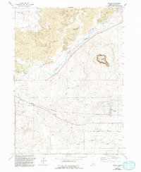
1971 Map of Dietrich
USGS Topo · Published 1993About this map
The Little Wood River and an intricate network of irrigation systems define the high desert landscape of Dietrich in this 1971 survey. The town center is characterized by its High Sch and proximity to the Main Canal, reflecting the region's total reliance on water engineering for agricultural viability. To the north, the volcanic history of the Snake River Plain is evident in the expanse of Lava, where a prominent Lava Crack and the volcanic cone of Crater Butte rise above the surrounding terrain. This map records a mid-century period of land use where an Old Railroad Grade and a Landing Strip contrast with the older natural features. The presence of specialized sites like Feedlots and a Gravel Pit underscores the local economy's focus on livestock and infrastructure maintenance during the early 1970s.
Find a feature on this map
21 named features on this map. Tap any name to fly to it.
Don’t see what you’re looking for? This feature index may not catch every label — zoom into the map to look around manually.
Map Details
Editions of this 1971 Dietrich Map
2 editions found
Other maps of this area

1955 · Twin Falls
USGS Topo · 1:250,000

1955 · Hailey
USGS Topo · 1:250,000

1958 · Twin Falls
USGS Topo · 1:250,000

1959 · Hailey
USGS Topo · 1:250,000

1962 · Hailey
USGS Topo · 1:250,000

1971 · Shoshone SE
USGS Topo · 1:24,000

1971 · Star Lake
USGS Topo · 1:24,000

1971 · Dietrich
USGS Topo · 1:24,000
1971 · Shoshone SW
USGS Topo · 1:24,000

1971 · Dietrich Butte
USGS Topo · 1:24,000