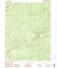
1986 Map of Digger Pine Flat
USGS Topo · Published 1996About this map
Deer Creek and the North Fork Mill Creek carve through the high country of Tehama County on this 1980s provisional study. The landscape is defined by the protected borders of the Ishi Wilderness and the Lassen National Forest, where a network of seasonal outposts and camps suggests a legacy of high-altitude ranching and forest management. Features like Apperson Cow Camp, Goat Camp, and Leininger Camp are connected by rugged 4wd tracks and trails, rather than paved roads, preserving a snapshot of this remote terrain before modern development. Notable landmarks such as Digger Pine Flat and Sulphur Springs highlight the geologic and botanical character of the region. The map also traces historic transit points across the waterways, including Twentymile Crossing and Six-Bit Crossing, which were essential for navigating the deep cuts of Twentymile Hollow.
Find a feature on this map
48 named features on this map. Tap any name to fly to it.
Don’t see what you’re looking for? This feature index may not catch every label — zoom into the map to look around manually.
Map Details
Editions of this 1986 Digger Pine Flat Map
4 editions found
Other maps of this area

1886 · Lassen Peak
USGS Topo · 1:250,000

1891 · Chico
USGS Topo · 1:125,000

1892 · Lassen Peak
USGS Topo · 1:250,000

1893 · Chico
USGS Topo · 1:125,000

1894 · Lassen Peak
USGS Topo · 1:250,000

1895 · Chico
USGS Topo · 1:125,000

1912 · Singer Creek
USGS Topo · 1:31,680

1935 · Paynes Creek
USGS Topo · 1:96,000

1941 · Mineral
USGS Topo · 1:125,000

1944 · Richardson Springs
USGS Topo · 1:62,500