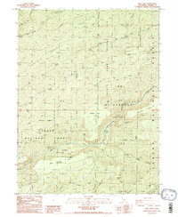
1986 Map of Ishi Caves
USGS Topo · Published 1986About this map
Ishi Caves (Yahi Indian Camp) serves as a significant cultural landmark within the Ishi Wilderness, a landscape shaped by deep canyons and volcanic ridges in the mid-1980s. This survey detail captures the complex drainage systems of the Lassen National Forest, where waterways like Mill Creek and Deer Creek have carved distinct flats and hollows, including Deer Creek Flat and the expansive Twentymile Hollow.
Find a feature on this map
44 named features on this map. Tap any name to fly to it.
Don’t see what you’re looking for? This feature index may not catch every label — zoom into the map to look around manually.
Map Details
Editions of this 1986 Ishi Caves Map
4 editions found
Other maps of this area

1886 · Lassen Peak
USGS Topo · 1:250,000

1891 · Chico
USGS Topo · 1:125,000

1892 · Lassen Peak
USGS Topo · 1:250,000

1893 · Chico
USGS Topo · 1:125,000

1894 · Lassen Peak
USGS Topo · 1:250,000

1895 · Chico
USGS Topo · 1:125,000

1912 · Singer Creek
USGS Topo · 1:31,680

1935 · Paynes Creek
USGS Topo · 1:96,000

1941 · Mineral
USGS Topo · 1:125,000

1944 · Richardson Springs
USGS Topo · 1:62,500