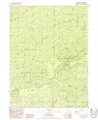
1986 Map of Ishi Caves
USGS Topo · Published 1986About this map
Ishi Caves (Yahi Indian Camp) serves as a primary cultural focal point in this portion of Tehama County, situated within the Ishi Wilderness and the Ishi State Game Refuge. The landscape is defined by the drainages of Mill Creek and Deer Creek, which have carved deep canyons through the Graham Pinery and various flats like Digger Pine Flat and Deer Creek Flat. This area preserves a legacy of remote seasonal habitations, indicated by numerous camps such as Apperson Cow Camp, Leininger Camp, and Skeleton Camp, which likely served ranching or hunting purposes in the late 20th century. Local landmarks like Moak Cave and Sulphur Lick further characterize the geologic and pastoral nature of the terrain. The presence of Grapevine Crossing and Deer Creek Crossing highlights the historical importance of established fords for traversing the canyon-cut highlands of the Lassen National Forest.
Find a feature on this map
43 named features on this map. Tap any name to fly to it.
Don’t see what you’re looking for? This feature index may not catch every label — zoom into the map to look around manually.
Map Details
Editions of this 1986 Ishi Caves Map
4 editions found
Other maps of this area

1886 · Lassen Peak
USGS Topo · 1:250,000

1891 · Chico
USGS Topo · 1:125,000

1892 · Lassen Peak
USGS Topo · 1:250,000

1893 · Chico
USGS Topo · 1:125,000

1894 · Lassen Peak
USGS Topo · 1:250,000

1895 · Chico
USGS Topo · 1:125,000

1912 · Singer Creek
USGS Topo · 1:31,680

1935 · Paynes Creek
USGS Topo · 1:96,000

1941 · Mineral
USGS Topo · 1:125,000

1944 · Richardson Springs
USGS Topo · 1:62,500