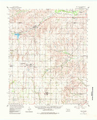
1957 Map of Dill City
USGS Topo · Published 1984About this map
Clinton-Sherman Air Force Base dominates the western landscape of Washita County in this mid-century survey, its expansive runways and facilities situated near Burns Flat. The area's settlement pattern is defined by a network of rural schools and cemeteries that mark the community's genealogy, including the Parkersburg Sch and Center Point Sch. These rural landmarks sit alongside the winding path of the Washita River and the engineered waters of Clinton Lake.
Find a feature on this map
54 named features on this map. Tap any name to fly to it.
Don’t see what you’re looking for? This feature index may not catch every label — zoom into the map to look around manually.
Map Details
Editions of this 1957 Dill City Map
3 editions found
Other maps of this area

1955 · Clinton
USGS Topo · 1:250,000

1956 · Cordell
USGS Topo · 1:62,500

1957 · Clinton
USGS Topo · 1:250,000

1957 · Butler
USGS Topo · 1:62,500

1957 · Clinton
USGS Topo · 1:62,500

1957 · Dill City
USGS Topo · 1:62,500

1960 · Hammon
USGS Topo · 1:62,500

1961 · Gotebo
USGS Topo · 1:62,500

1961 · Hobart
USGS Topo · 1:62,500

1961 · Retrop
USGS Topo · 1:62,500