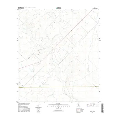
2016 Map of Dilley NE
USGS Topo · Published 2016About this map
The Frio River winds southeastward through this South Texas landscape, creating a riparian corridor that serves as the primary geographic feature of the region. The terrain is defined by its drainage systems, including the substantial Lockhardt Cr and Mule Cr, which converge toward the river valley. Human modification of the arid environment is evident through water management features such as Burns Reservoir and Thompson Lake. The rural infrastructure is supported by a network of county roads like Martin Branch Rd and the more formal FM 1583. Along the southern margin of the map, the political boundary of Frio Co La Salle Co indicates the transition between these two prominent cattle-country jurisdictions.
Find a feature on this map
14 named features on this map. Tap any name to fly to it.
Don’t see what you’re looking for? This feature index may not catch every label — zoom into the map to look around manually.
Map Details
Editions of this 2016 Dilley NE Map
This is the sole edition of this map. No revisions or reprints were ever made.
Other maps of this area

1925 · Pearsall 1-c
USGS Topo · 1:48,000

1927 · Pearsall
USGS Topo · 1:62,500

1934 · Schattel
USGS Topo · 1:62,500

1942 · Dilley
USGS Topo · 1:62,500

1953 · Crystal City
USGS Topo · 1:250,000

1955 · Crystal City
USGS Topo · 1:250,000

1956 · Hindes
USGS Topo · 1:62,500

1961 · Crystal City
USGS Topo · 1:250,000

1964 · Pearsall South
USGS Topo · 1:24,000
1964 · Derby
USGS Topo · 1:24,000