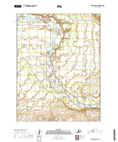
2019 Map of Dillingham A-1 SW
USGS Topo · Published 2019About this map
Alagnak Wild River defines the central corridor of this Alaskan landscape within the Lake and Peninsula Borough. The waterway, also designated as the Alagnak Wild and Scenic River, meanders through a complex system of braided channels and wetlands. This survey illustrates the intricate hydrography of the Alagnak River as it flows southeast, creating a shifting network of islands and sandbars. The surrounding terrain is primarily characterized by subtle topographic shifts and extensive low-lying drainage areas, typical of the Bristol Bay region's riverine environments. Mapping of this area highlights the preserved state of the river system, which remains largely untouched by permanent road infrastructure or settlements, reflecting its status as a protected wilderness corridor.
Find a feature on this map
8 named features on this map. Tap any name to fly to it.
Don’t see what you’re looking for? This feature index may not catch every label — zoom into the map to look around manually.
Map Details
Editions of this 2019 Dillingham A-1 SW Map
This is the sole edition of this map. No revisions or reprints were ever made.
Other maps of this area

1951 · Dillingham
USGS Topo · 1:250,000

1951 · Naknek D-1
USGS Topo · 1:63,360

1951 · Dillingham A-1
USGS Topo · 1:63,360

1952 · Naknek
USGS Topo · 1:250,000

1952 · Dillingham A-2
USGS Topo · 1:63,360

1952 · Naknek D-2
USGS Topo · 1:63,360

1954 · Dillingham
USGS Topo · 1:250,000

1964 · Naknek
USGS Topo · 1:250,000
2019 · Dillingham A-2 SE
USGS Topo · 1:25,000
2019 · Naknek D-1 NW
USGS Topo · 1:25,000