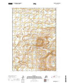
2019 Map of Naknek D-1 NW
USGS Topo · Published 2019About this map
Pauls Cr meanders across this subarctic landscape within the Lake and Peninsula Borough, defining the primary drainage for the surrounding wetlands and elevations. This 2019 survey, produced by the U.S. Geological Survey, maps a largely uninhabited territory where topographic contours reveal a series of gradual rises and depressions characteristic of the Bristol Bay region. The map captures the boundary between the Lake and Peninsula Borough and its neighbor, serving as a modern record of land divisions in this part of Alaska. While devoid of named settlements or roads, the intricate network of ponds and the course of the creek illustrate the natural water patterns essential for local ecology and potential resource management in the early 21st century.
Find a feature on this map
7 named features on this map. Tap any name to fly to it.
Don’t see what you’re looking for? This feature index may not catch every label — zoom into the map to look around manually.
Map Details
Editions of this 2019 Naknek D-1 NW Map
This is the sole edition of this map. No revisions or reprints were ever made.
Other maps of this area

1951 · Dillingham
USGS Topo · 1:250,000

1951 · Naknek D-1
USGS Topo · 1:63,360

1951 · Dillingham A-1
USGS Topo · 1:63,360

1952 · Naknek
USGS Topo · 1:250,000

1952 · Naknek D-2
USGS Topo · 1:63,360

1954 · Dillingham
USGS Topo · 1:250,000

1964 · Naknek
USGS Topo · 1:250,000
2019 · Naknek D-2 SE
USGS Topo · 1:25,000
2019 · Dillingham A-1 SW
USGS Topo · 1:25,000
2019 · Naknek D-1 SW
USGS Topo · 1:25,000