
1952 Map of Dillingham A-2
USGS Topo · Published 1958About this map
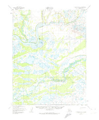
The Kvichak River and Alagnak River dominate this early 1950s landscape in southwest Alaska, showing the intricate hydrology of the Bristol Bay region before significant modern development. The map reveals a wild network of meandering channels, wetlands, and small ponds characteristic of this low-lying tundra. Human presence is sparse and temporary, evidenced by isolated groups of Cabins scattered along the riverbanks, likely serving as seasonal camps for fishing or trapping. Transportation is limited to the water or a solitary Winter Trail, reflecting a time when travel in this part of the Alaska-Third Judicial Division relied heavily on seasonal routes and river navigation. Survey control points like VABM Vich (171) provide the only fixed landmarks in a shifting terrain of bars and braids.
Find a feature on this map
5 named features on this map. Tap any name to fly to it.
Don’t see what you’re looking for? This feature index may not catch every label — zoom into the map to look around manually.
Map Details
Editions of this 1952 Dillingham A-2 Map
2 editions found
Other maps of this area

1951 · Dillingham
USGS Topo · 1:250,000

1951 · Dillingham A-1
USGS Topo · 1:63,360

1952 · Naknek
USGS Topo · 1:250,000

1952 · Naknek D-2
USGS Topo · 1:63,360

1952 · Dillingham A-3
USGS Topo · 1:63,360

1952 · Naknek D-3
USGS Topo · 1:63,360

1954 · Dillingham
USGS Topo · 1:250,000
1954 · Dillingham B-2
USGS Topo · 1:63,360

1954 · Dillingham B-3
USGS Topo · 1:63,360
1954 · Dillingham B-1
USGS Topo · 1:63,360