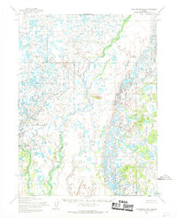
1954 Map of Dillingham B-2
USGS Topo · Published 1968About this map
Yellow Hill 2 rises above a vast expanse of glacial wetlands and unnamed kettle ponds in this mid-century survey of the Lake and Peninsula region. The landscape is dominated by a complex hydrological network of small lakes and winding drainage patterns, reflecting the remote interior wilderness near the Bristol Bay drainage. The only major named waterway on this specific sheet is Bear Courtney Creek, which meanders through the eastern portion of the quadrangle. This 1954 data, compiled by the Army Map Service, shows a terrain entirely devoid of roads or permanent settlements at the time of mapping, providing a baseline for the natural state of this Alaskan wilderness before modern development or environmental shifts altered the shoreline and marsh boundaries.
Find a feature on this map
2 named features on this map. Tap any name to fly to it.
Don’t see what you’re looking for? This feature index may not catch every label — zoom into the map to look around manually.
Map Details
Editions of this 1954 Dillingham B-2 Map
3 editions found
Other maps of this area

1951 · Dillingham
USGS Topo · 1:250,000

1951 · Dillingham A-1
USGS Topo · 1:63,360

1952 · Dillingham A-2
USGS Topo · 1:63,360

1952 · Dillingham A-3
USGS Topo · 1:63,360

1954 · Dillingham
USGS Topo · 1:250,000

1954 · Dillingham C-3
USGS Topo · 1:63,360

1954 · Dillingham C-1
USGS Topo · 1:63,360

1954 · Dillingham B-3
USGS Topo · 1:63,360

1954 · Dillingham C-2
USGS Topo · 1:63,360
1954 · Dillingham B-1
USGS Topo · 1:63,360