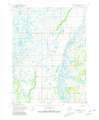
1954 Map of Dillingham B-2
USGS Topo · Published 1981About this map
The low-lying lake systems of southwestern Alaska are documented in this mid-century topographic record, based on aerial photography from the U.S. Geological Survey and the Army Map Service. The terrain is defined by a dense network of unnamed ponds and marshes characteristic of the tundra landscape between the Wood-Tikchik area and the coast. Only a few distinct landmarks break the watery expanse, most notably the rise of Yellow Hill and the winding course of Ben Courtney Creek in the eastern portion of the sheet. Surveyed in the early 1950s with minor revisions later in the century, the map illustrates a wilderness landscape devoid of established roads or trails at the time of its field annotation. It serves as a stark look at the hydrography of the region before more modern development, emphasizing the natural drainage patterns that have shaped this remote part of the Alaska Peninsula.
Find a feature on this map
2 named features on this map. Tap any name to fly to it.
Don’t see what you’re looking for? This feature index may not catch every label — zoom into the map to look around manually.
Map Details
Editions of this 1954 Dillingham B-2 Map
3 editions found
Other maps of this area

1951 · Dillingham
USGS Topo · 1:250,000

1951 · Dillingham A-1
USGS Topo · 1:63,360

1952 · Dillingham A-2
USGS Topo · 1:63,360

1952 · Dillingham A-3
USGS Topo · 1:63,360

1954 · Dillingham
USGS Topo · 1:250,000

1954 · Dillingham C-3
USGS Topo · 1:63,360

1954 · Dillingham C-1
USGS Topo · 1:63,360
1954 · Dillingham B-2
USGS Topo · 1:63,360

1954 · Dillingham B-3
USGS Topo · 1:63,360

1954 · Dillingham C-2
USGS Topo · 1:63,360