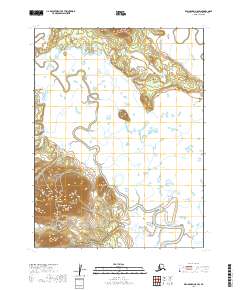
2019 Map of Dillingham A-8 SW
USGS Topo · Published 2019About this map
Manokotak sits at the foot of Gnarled Mtn, representing a significant point of human presence in this expansive subarctic landscape. The terrain is defined by the winding course of the Weary River, which meanders across the central and southern portions of the quadrangle before eventually approaching the Snake River in the northeast. The geography here is a complex arrangement of low-lying wetlands and tundra, interspersed with subtle elevation changes that direct the flow of these numerous seasonal and permanent waterways. The relationship between the settlement at Manokotak and the surrounding river system underscores the importance of inland water routes for transport and subsistence in the Dillingham region of Alaska. This topographic study detail the land's contours as they existed just before the turn of the decade.
Find a feature on this map
8 named features on this map. Tap any name to fly to it.
Don’t see what you’re looking for? This feature index may not catch every label — zoom into the map to look around manually.
Map Details
Editions of this 2019 Dillingham A-8 SW Map
This is the sole edition of this map. No revisions or reprints were ever made.
Other maps of this area

1945 · Nushagak Bay
USGS Topo · 1:250,000

1948 · Nushagak Bay D-4
USGS Topo · 1:63,360

1948 · Nushagak Bay D-3
USGS Topo · 1:63,360

1949 · Nushagak Bay
USGS Topo · 1:250,000

1951 · Dillingham
USGS Topo · 1:250,000

1951 · Goodnews
USGS Topo · 1:250,000

1951 · Nushagak Bay
USGS Topo · 1:250,000

1952 · Nushagak Bay D-3
USGS Topo · 1:63,360

1952 · Nushagak Bay D-4
USGS Topo · 1:63,360

1952 · Dillingham A-8
USGS Topo · 1:63,360