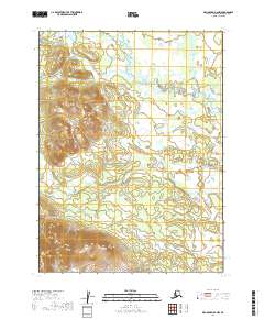
2019 Map of Dillingham B-6 NW
USGS Topo · Published 2019About this map
Okstukuk Hills dominates the western half of this remote Alaskan landscape, where the terrain rises sharply from the winding river valleys. The Kokwok River meanders through the northeast, carving a complex path across a low-lying basin characterized by numerous oxbows and marshy depressions. This 2019 survey documents a largely pristine wilderness within the Dillingham Census Area, showing the intricate hydrography of small tributaries like Kanukchuk Cr and Nameless Cr as they drain from the higher elevations. The map reveals the stark contrast between the steep, well-defined contours of the hills and the water-saturated plains of the river system, reflecting the classic glacial and periglacial geography of the region.
Find a feature on this map
8 named features on this map. Tap any name to fly to it.
Don’t see what you’re looking for? This feature index may not catch every label — zoom into the map to look around manually.
Map Details
Editions of this 2019 Dillingham B-6 NW Map
This is the sole edition of this map. No revisions or reprints were ever made.
Other maps of this area

1951 · Dillingham
USGS Topo · 1:250,000

1954 · Dillingham
USGS Topo · 1:250,000

1954 · Dillingham C-6
USGS Topo · 1:63,360

1954 · Dillingham B-7
USGS Topo · 1:63,360

1954 · Dillingham B-6
USGS Topo · 1:63,360

1954 · Dillingham C-7
USGS Topo · 1:63,360
2019 · Dillingham B-6 SW
USGS Topo · 1:25,000
2019 · Dillingham C-6 SE
USGS Topo · 1:25,000
2019 · Dillingham B-6 NE
USGS Topo · 1:25,000

2019 · Dillingham C-6 SW
USGS Topo · 1:25,000