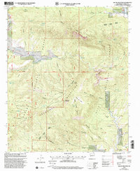
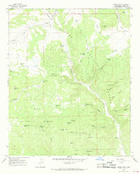
1999 Map of Dillon Mountain
USGS Topo · Published 2002About this map
San Francisco Mountains and the high desert canyons of Catron County dominate this late-twentieth-century landscape. The map highlights a network of vital water sources in an arid environment, including Toriette Lakes, Big Spring, and numerous named tanks such as Joshua Tank and Liedman Tank. These water points support the isolated Ranch operations and cattle corrals found at McCarty Flat and Higgins Flat. The transition from the Apache National Forest to the Gila National Forest occurs across varied terrain, from the narrow passage known as The Box to the flat expanse of Mess Box Mesa. Notable landmarks like Dillon Mountain and Monument Mountain tower over a labyrinth of drainages, including Cottonwood Canyon and Geronimo Canyon, where 4WD trails provide the primary means of navigation through the Quemado Reserve Ranger District.
Find a feature on this map
61 named features on this map. Tap any name to fly to it.
Don’t see what you’re looking for? This feature index may not catch every label — zoom into the map to look around manually.
Map Details
Editions of this 1999 Dillon Mountain Map
This is the sole edition of this map. No revisions or reprints were ever made.
Other maps of this area

1915 · Reserve
USGS Topo · 1:125,000

1918 · Reserve
USGS Topo · 1:125,000

1954 · Clifton
USGS Topo · 1:250,000

1957 · Clifton
USGS Topo · 1:250,000

1958 · Clifton
USGS Topo · 1:250,000

1962 · Clifton
USGS Topo · 1:250,000
1965 · Reserve
USGS Topo · 1:24,000
1965 · Milligan Mountain
USGS Topo · 1:24,000
1965 · Centerfire Bog
USGS Topo · 1:24,000
1965 · Queens Head
USGS Topo · 1:24,000