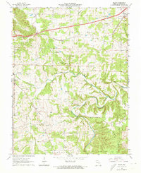
1963 Map of Dillon
USGS Topo · Published 1973About this map
St Louis San Francisco railroad tracks run through the northern reach of this Phelps County landscape, connecting the established community of St James with the settlement at Dillon. The terrain is defined by a dense network of winding waterways, including Dry Fork, Bourbeuse R, and Lanes Fork, which carve through the ridges. This mid-century survey reveals a rural landscape deeply rooted in family and faith, evidenced by numerous small burial grounds and places of worship such as the Smith-Laney Cem, Thomas Cem, and Bellview Ch. Educational life is scattered across the district at sites like Flat Grove Sch and Dean Sch, while industry is represented by a small Quarry and Claypit. A specialized glimpse of local infrastructure is visible at the Gaging Station and Dean Ford crossing, showing how residents navigated the Ozark waterways before modern bridge expansions.
Find a feature on this map
45 named features on this map. Tap any name to fly to it.
Don’t see what you’re looking for? This feature index may not catch every label — zoom into the map to look around manually.
Map Details
Editions of this 1963 Dillon Map
3 editions found
Other maps of this area

1912 · Rolla
USGS Topo · 1:62,500

1928 · Meramec Spring
USGS Topo · 1:62,500

1934 · Redbird
USGS Topo · 1:62,500

1937 · Vienna
USGS Topo · 1:62,500

1938 · Redbird
USGS Topo · 1:62,500

1938 · Vienna
USGS Topo · 1:48,000

1949 · Saint Louis
USGS Topo · 1:250,000

1949 · Vienna
USGS Topo · 1:62,500

1949 · Rolla
USGS Topo · 1:250,000

1949 · Meramec Spring
USGS Topo · 1:62,500