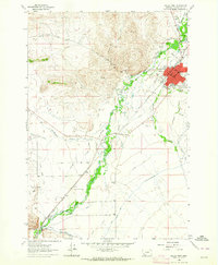
1963 Map of Dillon West
USGS Topo · Published 1964About this map
The Beaverhead River valley serves as a bustling corridor for transportation and agriculture in this early 1960s survey of Dillon. The city itself is the clear hub of activity, featuring the High School, Parkview School, and the local Fairground. The presence of the Union Pacific railroad and the Radio Tower (KDBM) highlights the area's mid-century role as a regional center for communication and transit.
Find a feature on this map
35 named features on this map. Tap any name to fly to it.
Don’t see what you’re looking for? This feature index may not catch every label — zoom into the map to look around manually.
Map Details
Editions of this 1963 Dillon West Map
2 editions found
Other maps of this area

1893 · Dillon
USGS Topo · 1:250,000

1952 · Argenta
USGS Topo · 1:24,000

1952 · Burns Mountain
USGS Topo · 1:24,000

1952 · Dalys
USGS Topo · 1:24,000

1952 · Gallagher Mountain
USGS Topo · 1:24,000

1955 · Dillon
USGS Topo · 1:250,000

1957 · Dillon
USGS Topo · 1:250,000

1958 · Dillon
USGS Topo · 1:250,000

1961 · Glen SE
USGS Topo · 1:24,000

1961 · Ashbough Canyon
USGS Topo · 1:24,000