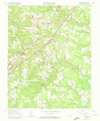
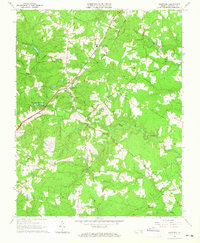
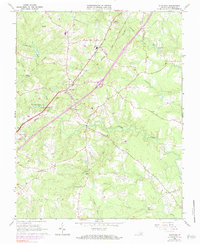
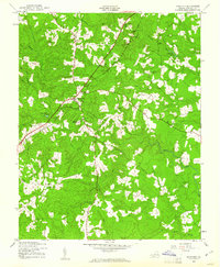
1963 Map of Dinwiddie
USGS Topo · Published 1972About this map
The Seaboard Coast Line railroad creates a sharp diagonal axis through this rural landscape, passing through the community of Dinwiddie and the small station site at Butterworth Depot. This mid-century survey illustrates a settlement pattern defined by small rural hubs and scattered family-named cemeteries such as the Wittpenn Cem and Wells Cem. Local education and religion are anchored by facilities like Southside High Sch and several country churches, including Mt Level Ch and St Thomas Ch near Hamilton. The terrain is characterized by winding watercourses like Stony Creek and its tributaries, Hawkins Branch and Mortar Branch, which create intricate drainage patterns across the timbered and agricultural lands of the Piedmont.
Find a feature on this map
30 named features on this map. Tap any name to fly to it.
Don’t see what you’re looking for? This feature index may not catch every label — zoom into the map to look around manually.
Map Details
Editions of this 1963 Dinwiddie Map
3 editions found
Other maps of this area

1894 · Petersburg
USGS Topo · 1:62,500

1897 · Amelia
USGS Topo · 1:125,000

1919 · Jarratt
USGS Topo · 1:62,500

1919 · Mc Kenney
USGS Topo · 1:48,000

1921 · Mc Kenney
USGS Topo · 1:62,500

1943 · Mc Kenney
USGS Topo · 1:62,500

1943 · De Witt
USGS Topo · 1:24,000
1943 · Dinwiddie
USGS Topo · 1:24,000

1943 · Church Road
USGS Topo · 1:24,000

1943 · Sutherland
USGS Topo · 1:24,000