
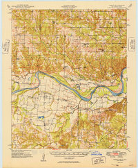
1949 Map of Direct
USGS Topo · Published 1949About this map
The Red River meanders through the heart of this landscape, defining the winding border between Oklahoma and Texas during the late 1940s. On the Oklahoma side, the territory is organized into the townships of Bennington and Hunter, where a network of rural schools like Crowder Prairie School and Iron Stob School served dispersed farming families. The settlement of Oberlin sits near the riverbank, once linked to the Texas side by the Oberlin Ferry. Across the water in Texas, the community of Direct acts as a local hub, surrounded by a dense collection of family landmarks including Mays Prairie Church and Corinth Ch. The terrain transitions from the low-lying wetlands of Crane Lake and Oberlin Lake to the rise of Bunker Hill, illustrating the complex drainage patterns of Bois d'Arc Creek and Whitegrass Creek before they reach the main river channel.
Find a feature on this map
65 named features on this map. Tap any name to fly to it.
Don’t see what you’re looking for? This feature index may not catch every label — zoom into the map to look around manually.
Map Details
Editions of this 1949 Direct Map
2 editions found
Other maps of this area

1899 · Atoka
USGS Topo · 1:125,000

1900 · Atoka
USGS Topo · 1:125,000

1901 · Antlers
USGS Topo · 1:125,000

1903 · Paris
USGS Topo · 1:125,000

1912 · Antlers
USGS Topo · 1:125,000

1925 · Antlers
USGS Topo · 1:125,000

1947 · Honey Grove
USGS Topo · 1:62,500

1948 · Grant
USGS Topo · 1:62,500

1948 · Paris
USGS Topo · 1:62,500

1948 · Direct
USGS Topo · 1:62,500