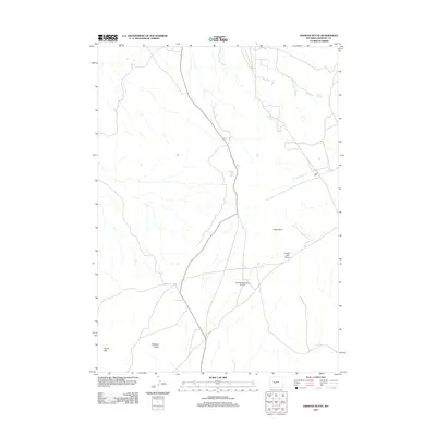
2012 Map of Dishpan Butte
USGS Topo · Published 2012About this map
Dishpan Butte and the surrounding high desert of Fremont County define this 2012 topographic study of the Wyoming landscape. The terrain is marked by essential water sources for ranching and wildlife, including Bear Spring, O'Brien Spring, and the curiously named Wagon Bed Spring. This era of the landscape is characterized by its sparse infrastructure, where cattle-range landmarks like the Government Meadows Windmill serve as primary navigational points across the open country. The eastern portion of the map is dominated by the prominent elevation of Cedar Rim, which falls away into Cedar Rim Draw. To the west, the topography narrows through the passage of Devils Gap. This survey documents a quiet interior of Wyoming where traditional land uses persist near the drainages of W Fork Long Cr, showing a network of ranch roads unchanged by modern development.
Find a feature on this map
9 named features on this map. Tap any name to fly to it.
Don’t see what you’re looking for? This feature index may not catch every label — zoom into the map to look around manually.
Map Details
Editions of this 2012 Dishpan Butte Map
This is the sole edition of this map. No revisions or reprints were ever made.
Other maps of this area

1951 · Myers Ranch
USGS Topo · 1:24,000

1953 · Blue Gulch
USGS Topo · 1:24,000

1953 · Bringolf Ranch
USGS Topo · 1:24,000

1953 · Sweetwater Station
USGS Topo · 1:24,000

1953 · Elkhorn Springs
USGS Topo · 1:24,000

1953 · Sand Draw
USGS Topo · 1:24,000

1953 · Dishpan Butte
USGS Topo · 1:24,000

1953 · Yellowstone Ranch
USGS Topo · 1:24,000

1953 · Red Canyon
USGS Topo · 1:24,000

1955 · Lander
USGS Topo · 1:250,000