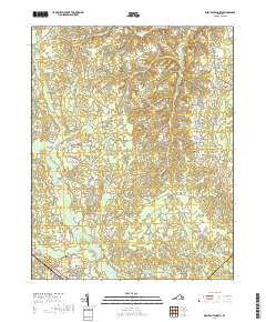
2019 Map of Disputanta North
USGS Topo · Published 2019About this map
Disputanta and Newville anchor this survey of the low-lying interior of Prince George County, where a complex network of waterways defines the landscape. The drainage patterns of the Blackwater Swamp and its tributaries, including the N Fork Blackwater Swamp and Second Swamp, illustrate the heavy riparian character of the region. Local history is grounded in sites such as the Bethlehem Congregational Church Cem and the small crossing at Hitchcock Bridge. Residential growth is evident in the northern reaches through named corridors like Greenbriar Blvd and Chieftain Rd, while the southern portion remains dominated by large wetland features like Otterdam Swamp and the collected waters of Thackets Ponds. The presence of established cemeteries like Newville Cem and Lebanon Cem offers clear points of reference for genealogical research in this rural Virginia landscape.
Find a feature on this map
75 named features on this map. Tap any name to fly to it.
Don’t see what you’re looking for? This feature index may not catch every label — zoom into the map to look around manually.
Map Details
Editions of this 2019 Disputanta North Map
This is the sole edition of this map. No revisions or reprints were ever made.
Other maps of this area

1894 · Bermuda Hundred
USGS Topo · 1:62,500

1894 · Petersburg
USGS Topo · 1:62,500

1918 · Charles City
USGS Topo · 1:62,500

1919 · Disputanta
USGS Topo · 1:62,500

1943 · Savedge
USGS Topo · 1:31,680

1943 · Hopewell
USGS Topo · 1:31,680

1943 · Disputanta
USGS Topo · 1:31,680

1943 · Richmond
USGS Topo · 1:250,000

1944 · Waverly
USGS Topo · 1:31,680
1944 · Nebletts Mill
USGS Topo · 1:31,680