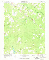
1968 Map of Disputanta South
USGS Topo · Published 1970About this map
The Norfolk and Western railway corridor dictates the settlement pattern across this Southside Virginia landscape, connecting the village of Disputanta in the northwest to the edge of the Waverly Airport in the southeast. This 1968 field-checked survey reveals a territory defined by an intricate network of wetlands, where the Blackwater River meets the expansive Warwick Swamp and Joseph Swamp. These water systems carve through the terrain, separated by small upland communities such as Newville and Centerville, and rural landmarks like Wilburn Church.
Find a feature on this map
30 named features on this map. Tap any name to fly to it.
Don’t see what you’re looking for? This feature index may not catch every label — zoom into the map to look around manually.
Map Details
Editions of this 1968 Disputanta South Map
3 editions found
Other maps of this area

1894 · Petersburg
USGS Topo · 1:62,500

1919 · Jarratt
USGS Topo · 1:62,500

1919 · Disputanta
USGS Topo · 1:62,500

1919 · Homeville
USGS Topo · 1:48,000

1920 · Homeville
USGS Topo · 1:62,500

1943 · Manry
USGS Topo · 1:31,680

1943 · Littleton
USGS Topo · 1:31,680

1943 · Savedge
USGS Topo · 1:31,680

1943 · Disputanta
USGS Topo · 1:31,680

1943 · Richmond
USGS Topo · 1:250,000