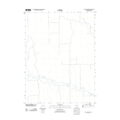
2011 Map of Dittons Creek
USGS Topo · Published 2011About this map
Dittons Creek winds through the high plains of Chase County, defining the drainage patterns of this agricultural landscape in the early 21st century. The map reveals a strictly organized section-line road network, where routes like 342 Ave and 742 Rd carve the terrain into the precise geometric blocks typical of Nebraska's farming country. While the upland reaches appear primarily as open range or cropland, the hydrology is anchored by several key watercourses. In the northeast, Stinking Water Creek crosses the grid, while the southern portion of the sheet is marked by the meandering path of Spring Creek. This USGS survey provides a detailed look at the rural infrastructure of the region, from the orientation of isolated farmsteads to the specific intersections of numbered county roads that facilitate the movement of goods and people across the vast prairie.
Find a feature on this map
16 named features on this map. Tap any name to fly to it.
Don’t see what you’re looking for? This feature index may not catch every label — zoom into the map to look around manually.
Map Details
Editions of this 2011 Dittons Creek Map
This is the sole edition of this map. No revisions or reprints were ever made.
Other maps of this area

1954 · McCook
USGS Topo · 1:250,000

1957 · McCook
USGS Topo · 1:250,000

1958 · McCook
USGS Topo · 1:250,000

1973 · Imperial NE
USGS Topo · 1:24,000

1973 · Dittons Creek NE
USGS Topo · 1:24,000

1973 · Enders
USGS Topo · 1:24,000

1973 · Dittons Creek NW
USGS Topo · 1:24,000

1973 · Imperial Municipal Airport
USGS Topo · 1:24,000

1974 · Dittons Creek SE
USGS Topo · 1:24,000
1974 · Wauneta West
USGS Topo · 1:24,000