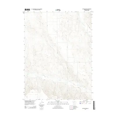
2014 Map of Dittons Creek
USGS Topo · Published 2014About this map
Stinking Water Cr and Dittons Cr carve through the agricultural tablelands of Chase County in this 2014 survey. The landscape is defined by a grid of rural section roads, including 340 Ave and 346th Ave, which connect isolated farmsteads and manage the undulating topography of the High Plains. Drainage patterns are prominent, with Spring Cr flowing through the southern portion of the quadrangle, illustrating the vital role of these intermittent and perennial waterways in the Nebraska panhandle's ecosystem. This modern topographic record captures the area's transition between managed ranching lands and the natural draws of the Republican River basin, providing a clear view of the rural infrastructure as it stood in the early twenty-first century.
Find a feature on this map
13 named features on this map. Tap any name to fly to it.
Don’t see what you’re looking for? This feature index may not catch every label — zoom into the map to look around manually.
Map Details
Editions of this 2014 Dittons Creek Map
This is the sole edition of this map. No revisions or reprints were ever made.
Other maps of this area

1954 · McCook
USGS Topo · 1:250,000

1957 · McCook
USGS Topo · 1:250,000

1958 · McCook
USGS Topo · 1:250,000

1973 · Imperial NE
USGS Topo · 1:24,000

1973 · Dittons Creek NE
USGS Topo · 1:24,000

1973 · Enders
USGS Topo · 1:24,000

1973 · Dittons Creek NW
USGS Topo · 1:24,000

1973 · Imperial Municipal Airport
USGS Topo · 1:24,000

1974 · Dittons Creek SE
USGS Topo · 1:24,000
1974 · Wauneta West
USGS Topo · 1:24,000