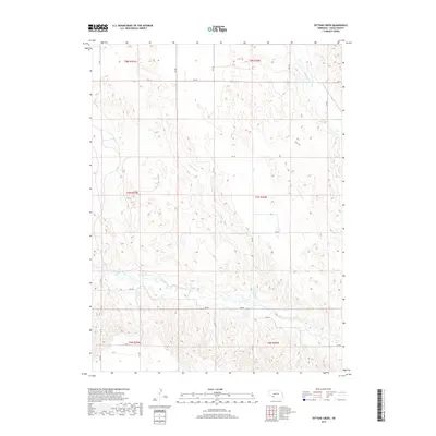
2017 Map of Dittons Creek
USGS Topo · Published 2017About this map
Dittons Creek meanders through this western Nebraska landscape, defining a terrain shaped by seasonal watercourses and a rigid section-line road grid. The map illustrates the sparsely populated ranching and agricultural character of Chase County, where the hydrology of Sinking Water Cr and Spring Cr dictates the local geography. The systematic organization of the land is evident in the alignment of thoroughfares like 324 Ave and 744 Rd, which facilitate movement across the wide-open township boundaries of t7n r36w and t8n r37w. This survey is a precise record of the modern rural infrastructure, showing the relationship between small intermittent streams and the expansive fields that comprise the High Plains environment.
Find a feature on this map
23 named features on this map. Tap any name to fly to it.
Don’t see what you’re looking for? This feature index may not catch every label — zoom into the map to look around manually.
Map Details
Editions of this 2017 Dittons Creek Map
This is the sole edition of this map. No revisions or reprints were ever made.
Other maps of this area

1954 · McCook
USGS Topo · 1:250,000

1957 · McCook
USGS Topo · 1:250,000

1958 · McCook
USGS Topo · 1:250,000

1973 · Imperial NE
USGS Topo · 1:24,000

1973 · Dittons Creek NE
USGS Topo · 1:24,000

1973 · Enders
USGS Topo · 1:24,000

1973 · Dittons Creek NW
USGS Topo · 1:24,000

1973 · Imperial Municipal Airport
USGS Topo · 1:24,000

1974 · Dittons Creek SE
USGS Topo · 1:24,000
1974 · Wauneta West
USGS Topo · 1:24,000