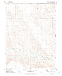
1974 Map of Dittons Creek
USGS Topo · Published 1977About this map
Stinking Water Creek and its seasonal tributaries carve a complex drainage pattern through the Chase County landscape, as documented in this 1974 field survey. The area is defined by its agricultural reliance on groundwater, evidenced by numerous wells scattered across the township sections. This mid-1970s record highlights the rural infrastructure of the High Plains, where natural waterways like Dittons Creek and Spring Creek dictate the local topography. Human activity is focused on resource extraction and land management, centered around a localized Gravel Pit and an extensive network of field lines and fences that partition the plains. The map provides a clear view of the transition between the rolling uplands and the creek bottoms before modern center-pivot irrigation further transformed the regional agricultural footprint.
Find a feature on this map
7 named features on this map. Tap any name to fly to it.
Don’t see what you’re looking for? This feature index may not catch every label — zoom into the map to look around manually.
Map Details
Editions of this 1974 Dittons Creek Map
This is the sole edition of this map. No revisions or reprints were ever made.
Other maps of this area

1954 · McCook
USGS Topo · 1:250,000

1957 · McCook
USGS Topo · 1:250,000

1958 · McCook
USGS Topo · 1:250,000

1973 · Imperial NE
USGS Topo · 1:24,000

1973 · Dittons Creek NE
USGS Topo · 1:24,000

1973 · Enders
USGS Topo · 1:24,000

1973 · Dittons Creek NW
USGS Topo · 1:24,000

1973 · Imperial Municipal Airport
USGS Topo · 1:24,000

1974 · Dittons Creek SE
USGS Topo · 1:24,000
1974 · Wauneta West
USGS Topo · 1:24,000