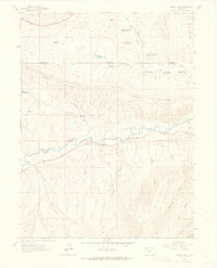
1962 Map of Divide Creek
USGS Topo · Published 1965About this map
The White River carves a central path through this terrain, where early 1960s infrastructure focuses heavily on water management and energy resources. A series of numbered reservoirs, including Divide Creek Reservoir No 4 and Lower Wolf Creek Reservoir No 2, suggests a landscape engineered for ranching or local industry along the Moffat Co Rio Blanco Co line. The prominent Coal Ridge dominates the northern half of the sheet, providing a geological anchor for the region's resource-based economy.
Find a feature on this map
36 named features on this map. Tap any name to fly to it.
Don’t see what you’re looking for? This feature index may not catch every label — zoom into the map to look around manually.
Map Details
Editions of this 1962 Divide Creek Map
2 editions found
Other maps of this area

1907 · Rangely
USGS Topo · 1:125,000

1907 · White River
USGS Topo · 1:125,000

1910 · White River
USGS Topo · 1:125,000

1910 · Rangely
USGS Topo · 1:125,000

1954 · Vernal
USGS Topo · 1:250,000

1958 · Vernal
USGS Topo · 1:250,000

1960 · Vernal
USGS Topo · 1:250,000

1960 · Elk Springs
USGS Topo · 1:62,500

1962 · Cactus Reservoir
USGS Topo · 1:24,000
1962 · Calamity Ridge
USGS Topo · 1:24,000