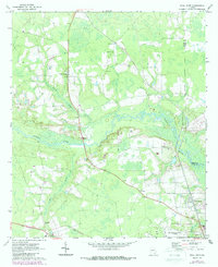
1971 Map of Dixie Union
USGS Topo · Published 1988About this map
Dixie Union and the surrounding piney woods of Ware County are defined by the meandering course of the Satilla River and its major tributaries like Dryden Creek and Kettle Creek. The landscape in the early 1970s reflects a rural community organized around small settlements and country churches, including Haywood Ch and Jordan Ch. Transportation and infrastructure are central themes on this sheet, featuring the Waycross-Ware County Airport and a significant highway project marked as Under Construction stretching toward Waresboro. Local recreation and civic life are anchored by the Drive-in Theater near Jamestown and the County Prison to the west. This survey also highlights several industrial and historical sites, such as a Sandpit near the Pierce County line and the old Waresboro Cem, providing a window into the region's mid-century development and land use.
Find a feature on this map
23 named features on this map. Tap any name to fly to it.
Don’t see what you’re looking for? This feature index may not catch every label — zoom into the map to look around manually.
Map Details
Editions of this 1971 Dixie Union Map
2 editions found
Other maps of this area

1953 · Waycross
USGS Topo · 1:250,000

1958 · Waycross
USGS Topo · 1:250,000

1967 · Waycross West
USGS Topo · 1:24,000

1967 · Pine Valley
USGS Topo · 1:24,000

1967 · Waycross East
USGS Topo · 1:24,000

1971 · Dixie Union
USGS Topo · 1:24,000

1971 · Beach
USGS Topo · 1:24,000

1971 · Talmo
USGS Topo · 1:24,000

1971 · Blackshear West
USGS Topo · 1:24,000

1971 · Mershon
USGS Topo · 1:24,000