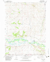
1982 Map of Dixon
USGS Topo · Published 1983About this map
The Little Snake River meanders across the border of Wyoming and Colorado, anchoring a landscape where high desert plateaus meet vital water resources. Near the small settlement of Dixon, the river's path is managed through an intricate system of irrigation including the First Mesa Ditch and West Side Canal. These features, along with the Gaging Sta on the riverbank, reflect the critical role of water management in sustaining agriculture on the surrounding flats like First Mesa and Dolan Mesa. Higher elevations to the north are marked by distinctive landmarks such as Red Monument and Muddy Mountain, while the Eversole Cem provides a genealogical touchstone for families established along the river valley. The map also records the Dixon Airport and numerous exploration markers, including several Drill Hole and Prospects locations, indicating the region's history of mineral prospecting and resource development.
Find a feature on this map
34 named features on this map. Tap any name to fly to it.
Don’t see what you’re looking for? This feature index may not catch every label — zoom into the map to look around manually.
Map Details
Editions of this 1982 Dixon Map
This is the sole edition of this map. No revisions or reprints were ever made.
Other maps of this area

1916 · Craig
USGS Topo · 1:125,000

1932 · Savery
USGS Topo · 1:96,000

1940 · Savery
USGS Topo · 1:125,000

1954 · Rawlins
USGS Topo · 1:250,000

1954 · Craig
USGS Topo · 1:250,000

1957 · Craig
USGS Topo · 1:250,000

1957 · Baggs
USGS Topo · 1:62,500

1958 · Rawlins
USGS Topo · 1:250,000

1958 · Craig
USGS Topo · 1:250,000

1960 · Craig
USGS Topo · 1:250,000