
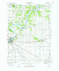
1950 Map of Dixon
USGS Topo · Published 1964About this map
Rock River dominates the center of this 1950 revision, carving a winding course through the borderlands of Ogle and Lee counties. The river passes through the iconic loop at Grand Detour and continues southwest into Dixon, where a concentrated grid of urban streets meets the main rail lines. The landscape is heavily marked by early 20th-century rural infrastructure, specifically an exceptionally high density of named country schools like Tealls Corners School, Red Birch School, and Britton School, reflecting the era's decentralized educational system before the rise of consolidated districts.
Find a feature on this map
87 named features on this map. Tap any name to fly to it.
Don’t see what you’re looking for? This feature index may not catch every label — zoom into the map to look around manually.
Map Details
Editions of this 1950 Dixon Map
2 editions found
Other maps of this area

1917 · Kings
USGS Topo · 1:62,500

1918 · Dixon
USGS Topo · 1:62,500

1918 · Kings
USGS Topo · 1:62,500

1922 · Oregon
USGS Topo · 1:62,500

1924 · Oregon
USGS Topo · 1:62,500

1930 · Woodsung
USGS Topo · 1:48,000

1942 · Forreston
USGS Topo · 1:62,500

1945 · Forreston
USGS Topo · 1:62,500

1946 · Sterling
USGS Topo · 1:62,500

1948 · Sterling
USGS Topo · 1:62,500