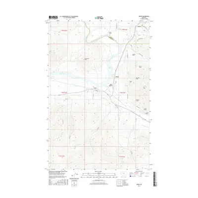
2017 Map of Dixon
USGS Topo · Published 2017About this map
The confluence of the Flathead River and the Jocko River defines the landscape of this region on the border of Sanders and Lake Counties. The settlement of Dixon serves as a central point, situated near the historic locations of Old Agency and Agency. The map reveals an intricate water management system essential to the valley's character, including the Revais Canal, Lower Jocko 1 Canal, and Mission H Canal. To the north, the terrain transitions into the Moiese Valley near Moiese, while the eastern portion of the map is marked by the complex topography of the Bison Range, featuring landmarks such as Buffalo Basin and Fescue Ridge. Genealogists and local historians can locate the Dixon Cem and trace early road networks like Bison Range Rd and Red Sleep Mountain Dr as they wind through the varied elevations of Communion Butte and Red Mans Ridge.
Find a feature on this map
50 named features on this map. Tap any name to fly to it.
Don’t see what you’re looking for? This feature index may not catch every label — zoom into the map to look around manually.
Map Details
Editions of this 2017 Dixon Map
This is the sole edition of this map. No revisions or reprints were ever made.
Other maps of this area

1956 · Wallace
USGS Topo · 1:250,000

1959 · Alberton
USGS Topo · 1:62,500

1959 · Arlee
USGS Topo · 1:62,500

1960 · Wallace
USGS Topo · 1:250,000

1964 · Dixon
USGS Topo · 1:24,000

1964 · Mc Donald
USGS Topo · 1:24,000

1964 · Melton Ranch
USGS Topo · 1:24,000

1964 · Ravalli
USGS Topo · 1:24,000

1965 · Sloan
USGS Topo · 1:24,000
1965 · Charlo
USGS Topo · 1:24,000