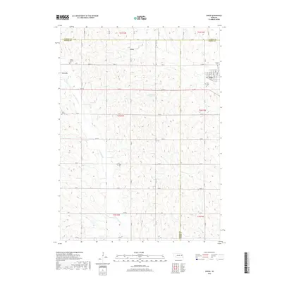
2017 Map of Dodge
USGS Topo · Published 2017About this map
Dodge and Howells anchor this agricultural landscape at the tri-county junction of Cuming, Colfax, and Dodge Counties. The terrain is defined by the winding course of the E Fork Maple Cr and Silver Cr, which cut through a dense grid of section roads. The small settlement of Olean sits near the northern boundary, while a network of rural burial grounds reveals the area's deep family roots and early parish history. These include the S S Peter and Paul Cem, Saint Joseph Cem, and Tabor Cem. The map illustrates the persistent structure of Nebraska's rural sections, where the town of Dodge shows a concentrated residential grid at its center, surrounded by a largely uninterrupted pattern of farm holdings and seasonal creek beds.
Find a feature on this map
45 named features on this map. Tap any name to fly to it.
Don’t see what you’re looking for? This feature index may not catch every label — zoom into the map to look around manually.
Map Details
Editions of this 2017 Dodge Map
This is the sole edition of this map. No revisions or reprints were ever made.
Other maps of this area

1955 · Fremont
USGS Topo · 1:250,000

1957 · Fremont
USGS Topo · 1:250,000

1958 · Fremont
USGS Topo · 1:250,000

1966 · Monterey
USGS Topo · 1:24,000

1966 · Webster
USGS Topo · 1:24,000

1966 · Snyder
USGS Topo · 1:24,000

1966 · Aloys
USGS Topo · 1:24,000

1966 · Clarkson
USGS Topo · 1:24,000
1966 · Stanton SE
USGS Topo · 1:24,000

1966 · Dodge SW
USGS Topo · 1:24,000