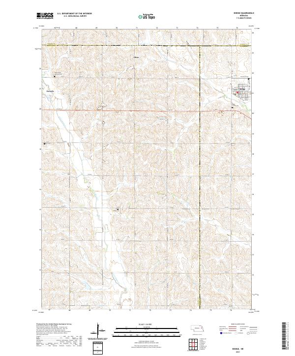
2021 Map of Dodge
USGS Topo · Published 2021About this map
The agricultural heartland where Cuming, Colfax, and Dodge counties meet is defined by the winding paths of E Fork Maple Cr and Silver Cr. This 2021 survey shows a landscape of section-line roads and scattered family-history sites, including Saints Peter and Paul Cem near the western edge. The town of Dodge serves as a local hub on the eastern border, with its grid of streets such as Front St and Pine St leading out to the surrounding farmland. The smaller settlement of Howells sits to the west, while the locality of Olean remains a point of interest for those tracing the rural development of the region. Numerous burial grounds, such as Tabor Cem and Grove Hill Cem, provide specific points of reference for genealogists studying the generational settlements of these Nebraska prairie townships.
Find a feature on this map
49 named features on this map. Tap any name to fly to it.
Don’t see what you’re looking for? This feature index may not catch every label — zoom into the map to look around manually.
Map Details
Editions of this 2021 Dodge Map
This is the sole edition of this map. No revisions or reprints were ever made.
Other maps of this area

1955 · Fremont
USGS Topo · 1:250,000

1957 · Fremont
USGS Topo · 1:250,000

1958 · Fremont
USGS Topo · 1:250,000

1966 · Monterey
USGS Topo · 1:24,000

1966 · Webster
USGS Topo · 1:24,000

1966 · Snyder
USGS Topo · 1:24,000

1966 · Aloys
USGS Topo · 1:24,000

1966 · Clarkson
USGS Topo · 1:24,000
1966 · Stanton SE
USGS Topo · 1:24,000

1966 · Dodge SW
USGS Topo · 1:24,000