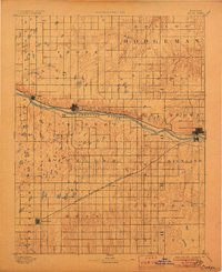
1892 Map of Dodge
USGS Topo · Published 1906About this map
The Arkansas River serves as the primary artery for settlement and industry across this high plains landscape at the end of the 19th century. To the north, the Atchison Topeka and Santa Fe Railroad tracks parallel the river, supporting the established hubs of Dodge, Cimarron, and Ingalls. The presence of the Eureka Irrigating Canal branching off the river near Howell highlights the early efforts to transform this semi-arid terrain through large-scale water management.
Find a feature on this map
28 named features on this map. Tap any name to fly to it.
Don’t see what you’re looking for? This feature index may not catch every label — zoom into the map to look around manually.
Map Details
Editions of this 1892 Dodge Map
4 editions found
Other maps of this area

1892 · Ness
USGS Topo · 1:125,000

1892 · Meade
USGS Topo · 1:125,000

1892 · Dodge
USGS Topo · 1:125,000

1892 · Spearville
USGS Topo · 1:125,000

1894 · Spearville
USGS Topo · 1:125,000

1894 · Ness
USGS Topo · 1:125,000

1896 · Garden
USGS Topo · 1:125,000

1896 · Ashland
USGS Topo · 1:125,000

1955 · Great Bend
USGS Topo · 1:250,000

1955 · Pratt
USGS Topo · 1:250,000