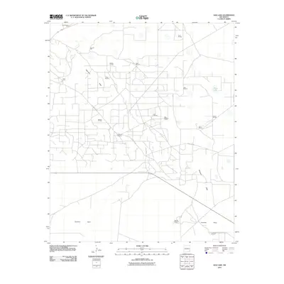
2010 Map of Dog Lake
USGS Topo · Published 2010About this map
Mescalero Ridge cuts across this high desert landscape, defining the transition between the elevated plains and the wide expanse of the Querecho Plains below. In the early 21st century, this corner of Lea County is characterized by a dense network of resource extraction roads supporting numerous petroleum operations. Large-scale energy production is evident in the Maljamar Oil Field, Sannel Oil Field, and Leamex Oil Field, which dominate the local geography alongside industrial sites like Caprock Sand and Gravel. Despite the industrial footprint, traditional ranching persists at the Taylor-Holaman Ranch and Taylor Ranch. The scarcity of surface water is underscored by a reliance on named groundwater sources and livestock infrastructure, including Three Well Windmill, Cogburn Windmill, and Steel Windmill, while White Lake and Dog Lake Well provide the primary natural hydrological markers in this arid environment.
Find a feature on this map
22 named features on this map. Tap any name to fly to it.
Don’t see what you’re looking for? This feature index may not catch every label — zoom into the map to look around manually.
Map Details
Editions of this 2010 Dog Lake Map
This is the sole edition of this map. No revisions or reprints were ever made.
Other maps of this area

1942 · Clayton Basin
USGS Topo · 1:62,500

1943 · Clayton Basin
USGS Topo · 1:62,500

1954 · Hobbs
USGS Topo · 1:250,000

1958 · Hobbs
USGS Topo · 1:250,000

1962 · Buckeye
USGS Topo · 1:62,500

1963 · Laguna Gatuna
USGS Topo · 1:62,500

1963 · Maljamar
USGS Topo · 1:62,500

1984 · Ironhouse Well
USGS Topo · 1:24,000

1984 · Laguna Gatuna NW
USGS Topo · 1:24,000
1985 · Buckeye NW
USGS Topo · 1:24,000