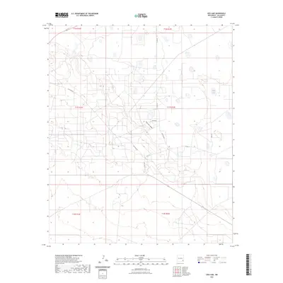
2023 Map of Dog Lake
USGS Topo · Published 2023About this map
Mescalero Ridge cuts across this high plains landscape in Lea County, defining the western edge of the Llano Estacado. This 2023 survey illustrates the modern grid of rural access roads that support the region's ranching and industrial activities, including Mescalero Rd, Dog Lake Rd, and Derby Rd. The arid terrain is punctuated by numerous depressions and ephemeral catchments, most notably White Lake and the area designated as Tomahawk. The township and range lines, such as t17s r32e and t17s r33e, provide a structural framework for understanding land division in this section of New Mexico, where the vast, open character of the Chihuahuan Desert meets the caprock.
Find a feature on this map
15 named features on this map. Tap any name to fly to it.
Don’t see what you’re looking for? This feature index may not catch every label — zoom into the map to look around manually.
Map Details
Editions of this 2023 Dog Lake Map
This is the sole edition of this map. No revisions or reprints were ever made.
Other maps of this area

1942 · Clayton Basin
USGS Topo · 1:62,500

1943 · Clayton Basin
USGS Topo · 1:62,500

1954 · Hobbs
USGS Topo · 1:250,000

1958 · Hobbs
USGS Topo · 1:250,000

1962 · Buckeye
USGS Topo · 1:62,500

1963 · Laguna Gatuna
USGS Topo · 1:62,500

1963 · Maljamar
USGS Topo · 1:62,500

1984 · Ironhouse Well
USGS Topo · 1:24,000

1984 · Laguna Gatuna NW
USGS Topo · 1:24,000
1985 · Buckeye NW
USGS Topo · 1:24,000