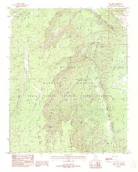
1988 Map of Dog Point
USGS Topo · Published 1988About this map
Saddle Mountain rises as a central landmark in this remote corner of Northern Arizona, where the high-altitude terrain of the Kaibab National Forest meets the protected reaches of the Grand Canyon National Game Preserve. The landscape is defined by deep incisions like Tater Canyon and Wildcat Canyon, illustrating the complex drainage patterns of the Colorado River's north rim. The presence of water sources such as Tater Canyon Springs, Crystal Spring, and the high-elevation Dog Lake highlights the critical infrastructure for both wildlife and early range management in this arid environment. Significant geological features, including the Marble Sinkhole and Wildcat Cave, offer specific points of interest for those studying the karst topography of the region. Transportation across these ridges is preserved through historic routes like the Upper Dog Canyon Pack Trail, providing evidence of how this territory was navigated before modern road development.
Find a feature on this map
28 named features on this map. Tap any name to fly to it.
Don’t see what you’re looking for? This feature index may not catch every label — zoom into the map to look around manually.
Map Details
Editions of this 1988 Dog Point Map
2 editions found
Other maps of this area

1886 · Echo Cliffs
USGS Topo · 1:250,000

1886 · Kaibab
USGS Topo · 1:250,000

1891 · Echo Cliffs
USGS Topo · 1:250,000

1936 · Jacobs Lake
USGS Topo · 1:48,000

1940 · Jacob Lake
USGS Topo · 1:62,500

1953 · Jacobs Lake
USGS Topo · 1:62,500

1953 · Grand Canyon
USGS Topo · 1:250,000

1954 · Nankoweap
USGS Topo · 1:62,500

1954 · Emmett Wash
USGS Topo · 1:62,500

1956 · Marble Canyon
USGS Topo · 1:250,000