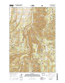
2014 Map of Dog River
USGS Topo · Published 2014About this map
The Upper Hood River Valley serves as a central corridor for this 2014 survey of Mount Hood National Forest. The landscape is dominated by the complex drainage systems of the E Fork Hood River and Dog River, which carve through the high elevations of Bluegrass Ridge and the Mill Creek Buttes. This modern topographic study illustrates the intricate network of forest service roads, such as Dufur Mill Rd and Brooks Meadow Rd, that provide access to high-country clearings. These alpine openings include Gibson Prairie, Brooks Meadow, and Horkelia Meadow, which remain significant landmarks for regional navigation and resource management. The map also documents numerous named water sources, from Crystal Spring in the west to Blue Bucket Spring in the south, essential features for the forestry and recreation-based economy of the Cascades.
Find a feature on this map
71 named features on this map. Tap any name to fly to it.
Don’t see what you’re looking for? This feature index may not catch every label — zoom into the map to look around manually.
Map Details
Editions of this 2014 Dog River Map
This is the sole edition of this map. No revisions or reprints were ever made.
Other maps of this area

1924 · Mount Hood
USGS Topo · 1:125,000

1926 · Hood River
USGS Topo · 1:125,000

1927 · Mount Hood
USGS Topo · 1:125,000

1929 · Hood River
USGS Topo · 1:125,000

1930 · Dufur
USGS Topo · 1:125,000

1934 · Dufur
USGS Topo · 1:125,000

1934 · The Dalles
USGS Topo · 1:125,000

1953 · The Dalles
USGS Topo · 1:250,000

1956 · The Dalles
USGS Topo · 1:250,000

1957 · The Dalles
USGS Topo · 1:250,000