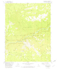
1979 Map of Dogwood Peak
USGS Topo · Published 1979About this map
The Middle Fork Feather River carves a deep path through this portion of the Plumas National Forest, defining a landscape where river bars and steep ridges dictated human activity. In this late 1970s survey, the presence of the Little California Mine and the Dejonah Creek Mine points to the area's enduring mineral interest, while named locations like Cleghorn Bar and Carpenter Bar reveal the historical importance of river-level landings.
Find a feature on this map
47 named features on this map. Tap any name to fly to it.
Don’t see what you’re looking for? This feature index may not catch every label — zoom into the map to look around manually.
Map Details
Editions of this 1979 Dogwood Peak Map
3 editions found
Other maps of this area

1888 · Bidwell Bar
USGS Topo · 1:125,000

1891 · Bidwell Bar
USGS Topo · 1:125,000

1891 · Downieville
USGS Topo · 1:125,000

1893 · Bidwell Bar
USGS Topo · 1:125,000

1893 · Downieville
USGS Topo · 1:125,000

1895 · Bidwell Bar
USGS Topo · 1:125,000

1895 · Downieville
USGS Topo · 1:125,000

1896 · Downieville
USGS Topo · 1:125,000

1897 · Bidwell Bar
USGS Topo · 1:125,000

1897 · Downieville
USGS Topo · 1:125,000