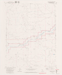
1979 Map of Dogwood Peak
USGS Topo · Published 1979About this map
Feather River Wild and Scenic River corridors define this portion of the Plumas National Forest, where the terrain is dominated by the deep canyon of the Middle Fork Feather River. The map reveals a landscape shaped by both natural drainage and historical resource extraction, evidenced by the Little California Mine and the Dejonah Creek Mine. Transport and access are limited to a network of trails and jeep tracks that traverse prominent high points like Dogwood Peak and Table Mountain. This 1970s survey captures the area's character as a managed wilderness, highlighting recreational sites such as Cleghorn Bar Campground alongside geographic landmarks like Hartman Bar Ridge and Franklin Hill. The density of water features, including Morrow Creek and the S Br Middle Fk Feather River, underscores the complex hydrology that feeds into the river system.
Find a feature on this map
41 named features on this map. Tap any name to fly to it.
Don’t see what you’re looking for? This feature index may not catch every label — zoom into the map to look around manually.
Map Details
Editions of this 1979 Dogwood Peak Map
3 editions found
Other maps of this area

1888 · Bidwell Bar
USGS Topo · 1:125,000

1891 · Bidwell Bar
USGS Topo · 1:125,000

1891 · Downieville
USGS Topo · 1:125,000

1893 · Bidwell Bar
USGS Topo · 1:125,000

1893 · Downieville
USGS Topo · 1:125,000

1895 · Bidwell Bar
USGS Topo · 1:125,000

1895 · Downieville
USGS Topo · 1:125,000

1896 · Downieville
USGS Topo · 1:125,000

1897 · Bidwell Bar
USGS Topo · 1:125,000

1897 · Downieville
USGS Topo · 1:125,000