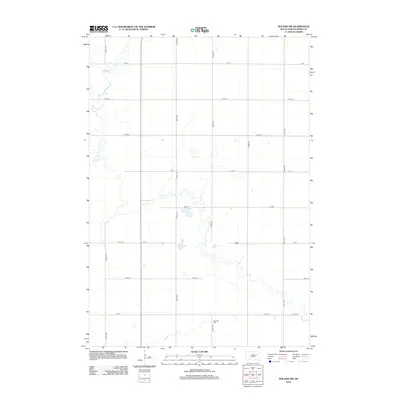
2012 Map of Doland SW
USGS Topo · Published 2012About this map
The low-lying plains of Timber Cr define this rural landscape in Spink County, where the meandering waterway winds through a grid of section-line roads. This part of Belle Plaine Township is characterized by its agricultural layout, marked by the intersection of north-south corridors like 401st Ave and 402nd Ave with east-west routes such as 178th St. The most significant historical and genealogical landmark on the sheet is Ebenezer Cem, located along the southern edge near 181st St. The terrain is punctuated by numerous small depressions and seasonal wetlands typical of the prairie pothole region, offering a clear view of the drainage patterns and land usage in this section of South Dakota in the early 21st century.
Find a feature on this map
17 named features on this map. Tap any name to fly to it.
Don’t see what you’re looking for? This feature index may not catch every label — zoom into the map to look around manually.
Map Details
Editions of this 2012 Doland SW Map
This is the sole edition of this map. No revisions or reprints were ever made.
Other maps of this area

1895 · Byron
USGS Topo · 1:125,000

1953 · Frankfort
USGS Topo · 1:24,000

1953 · Huron
USGS Topo · 1:250,000

1954 · Huron
USGS Topo · 1:250,000

1956 · Lake Byron NW
USGS Topo · 1:24,000

1956 · Glendale Colony
USGS Topo · 1:24,000

1956 · Spink Colony
USGS Topo · 1:24,000

1956 · Doland SW
USGS Topo · 1:24,000
1971 · Doland NW
USGS Topo · 1:24,000
1971 · Doland
USGS Topo · 1:24,000
Featured Places
- Belle Plaine Township, SD
- Harrison Township, SD
- Lincoln Township, SD
- Frankfort Township, SD
- Spink County, SD