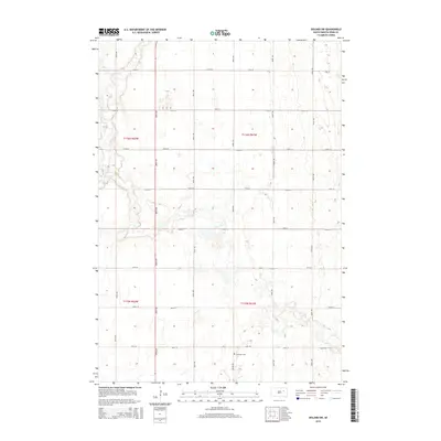
2015 Map of Doland SW
USGS Topo · Published 2015About this map
The agrarian landscape of Spink County is captured here in a meticulously gridded layout of section lines and gravel roads. Ebenezer Cem serves as a significant landmark for genealogical research in this rural expanse, situated near the intersection of 181st St and 402nd Ave. The terrain is defined by the winding course of Timber Cr, which cuts through the northwestern townships of T116n R62w and T115n R62w. This 2015 survey reflects the enduring structure of the Public Land Survey System, showing how the midwestern prairie was partitioned into predictable townships and sections that continue to dictate local travel and land ownership today.
Find a feature on this map
20 named features on this map. Tap any name to fly to it.
Don’t see what you’re looking for? This feature index may not catch every label — zoom into the map to look around manually.
Map Details
Editions of this 2015 Doland SW Map
This is the sole edition of this map. No revisions or reprints were ever made.
Other maps of this area

1895 · Byron
USGS Topo · 1:125,000

1953 · Frankfort
USGS Topo · 1:24,000

1953 · Huron
USGS Topo · 1:250,000

1954 · Huron
USGS Topo · 1:250,000

1956 · Lake Byron NW
USGS Topo · 1:24,000

1956 · Glendale Colony
USGS Topo · 1:24,000

1956 · Spink Colony
USGS Topo · 1:24,000

1956 · Doland SW
USGS Topo · 1:24,000
1971 · Doland NW
USGS Topo · 1:24,000
1971 · Doland
USGS Topo · 1:24,000
Featured Places
- Belle Plaine Township, SD
- Harrison Township, SD
- Lincoln Township, SD
- Frankfort Township, SD
- Spink County, SD