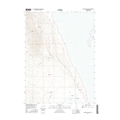
2017 Map of Dolphin Island West
USGS Topo · Published 2017About this map
The Hogup Mountains dominate the western landscape of this Box Elder County region, where steep slopes descend toward the salt flats and shoreline of the Great Salt Lake. This 2017 survey details the complex network of primitive roads and tracks that navigate the foothills, including Sheep Camp RD and Middle Hogup RD, reflecting the area's history of seasonal grazing and remote land management. To the east, the map captures the transition to the lake's edge at Clyman Bay, punctuated by the distinct landform of Dolphin Island. Isolated landmarks such as Deadman Knoll and The Fingerpoint serve as critical navigational markers in this sparse, arid environment. The presence of Big Wash and Big Pass further illustrates the drainage patterns and natural corridors used to traverse this challenging terrain between the mountains and the water.
Find a feature on this map
16 named features on this map. Tap any name to fly to it.
Don’t see what you’re looking for? This feature index may not catch every label — zoom into the map to look around manually.
Map Details
Editions of this 2017 Dolphin Island West Map
This is the sole edition of this map. No revisions or reprints were ever made.
Other maps of this area

1954 · Brigham City
USGS Topo · 1:250,000

1958 · Brigham City
USGS Topo · 1:250,000

1962 · Brigham City
USGS Topo · 1:250,000

1969 · Spring Bay SW
USGS Topo · 1:24,000

1969 · Dolphin Island West
USGS Topo · 1:24,000

1969 · Gunnison Island SW
USGS Topo · 1:24,000
1969 · Dolphin Island East
USGS Topo · 1:24,000

1969 · Hogup Ridge North
USGS Topo · 1:24,000

1969 · Hogup Bar
USGS Topo · 1:24,000
1969 · Crocodile Mtn SE
USGS Topo · 1:24,000