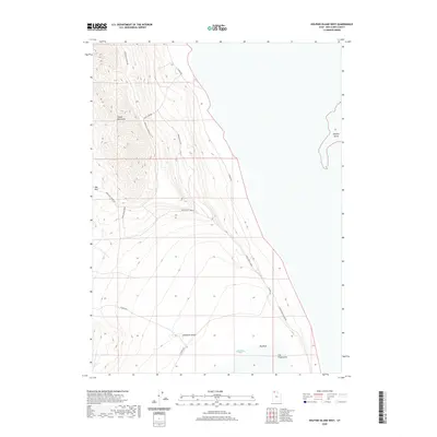
2020 Map of Dolphin Island West
USGS Topo · Published 2020About this map
The Hogup Mountains dominate the western landscape of this Box Elder County region, rising sharply above the shoreline of the Great Salt Lake. This 2020 survey illustrates a stark desert environment where terrain features like Deadman Knoll and the Big Wash define the local geography. Human passage through this arid terrain is marked by a network of ranching and utility roads, including Upper East Hogup Rd and Sheep Camp Rd, which navigate the slopes and canyons. To the east, the map captures the transition from land to water at Clyman Bay, where Dolphin Island stands as a prominent landform within the lake's expanse. The intricate contour lines detail the complex ridges of the Upper North Finger, providing a clear view of the drainage patterns and elevation changes across this remote stretch of northern Utah.
Find a feature on this map
13 named features on this map. Tap any name to fly to it.
Don’t see what you’re looking for? This feature index may not catch every label — zoom into the map to look around manually.
Map Details
Editions of this 2020 Dolphin Island West Map
This is the sole edition of this map. No revisions or reprints were ever made.
Other maps of this area

1954 · Brigham City
USGS Topo · 1:250,000

1958 · Brigham City
USGS Topo · 1:250,000

1962 · Brigham City
USGS Topo · 1:250,000

1969 · Spring Bay SW
USGS Topo · 1:24,000

1969 · Dolphin Island West
USGS Topo · 1:24,000

1969 · Gunnison Island SW
USGS Topo · 1:24,000
1969 · Dolphin Island East
USGS Topo · 1:24,000

1969 · Hogup Ridge North
USGS Topo · 1:24,000

1969 · Hogup Bar
USGS Topo · 1:24,000
1969 · Crocodile Mtn SE
USGS Topo · 1:24,000