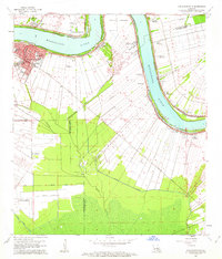
1962 Map of Donaldsonville
USGS Topo · Published 1963About this map
Donaldsonville sits at a sharp bend in the Mississippi River, serving as a central hub for the surrounding river parishes in the early 1960s. The landscape is defined by the traditional long-lot plantation system, with narrow tracts extending back from the riverbanks. Several of these named estates, including Union Plantation, St Mary Plantation, and Dugas Plantation, are still clearly delineated, illustrating the enduring agricultural patterns of the region. The town itself shows significant development, featuring schools like Lowery High School and Ascension High School, alongside a local Fairground.
Find a feature on this map
45 named features on this map. Tap any name to fly to it.
Don’t see what you’re looking for? This feature index may not catch every label — zoom into the map to look around manually.
Map Details
Editions of this 1962 Donaldsonville Map
4 editions found
Other maps of this area

1892 · Donaldsonville
USGS Topo · 1:62,500

1892 · Thibodaux
USGS Topo · 1:62,500

1927 · Thibodaux NW
USGS Topo · 1:31,680

1932 · Thibodaux NE
USGS Topo · 1:31,680

1935 · Gonzales
USGS Topo · 1:31,680

1936 · White Castle
USGS Topo · 1:62,500

1939 · Donaldsonville
USGS Topo · 1:62,500

1940 · Lagan
USGS Topo · 1:31,680

1940 · Madewood
USGS Topo · 1:31,680

1945 · New Orleans
USGS Topo · 1:250,000