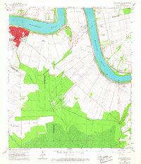
1962 Map of Donaldsonville
USGS Topo · Published 1967About this map
Donaldsonville serves as the focal point of this riverbend landscape, situated where the Mississippi River meets the head of Bayou Lafourche. The 1960s riverfront reflects a deep history of sugar production and river commerce, evidenced by the numerous named estates such as Dugas Plantation, Union Plantation, and St Mary Plantation. These agricultural tracts, bounded by an extensive levee system, are bisected by the Texas and Pacific railroad, which provided a vital link between the river settlements and inland markets.
Find a feature on this map
48 named features on this map. Tap any name to fly to it.
Don’t see what you’re looking for? This feature index may not catch every label — zoom into the map to look around manually.
Map Details
Editions of this 1962 Donaldsonville Map
4 editions found
Other maps of this area

1892 · Donaldsonville
USGS Topo · 1:62,500

1892 · Thibodaux
USGS Topo · 1:62,500

1927 · Thibodaux NW
USGS Topo · 1:31,680

1932 · Thibodaux NE
USGS Topo · 1:31,680

1935 · Gonzales
USGS Topo · 1:31,680

1936 · White Castle
USGS Topo · 1:62,500

1939 · Donaldsonville
USGS Topo · 1:62,500

1940 · Lagan
USGS Topo · 1:31,680

1940 · Madewood
USGS Topo · 1:31,680

1945 · New Orleans
USGS Topo · 1:250,000