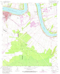
1962 Map of Donaldsonville
USGS Topo · Published 1981About this map
The Mississippi River creates a dramatic series of bends here, anchoring a landscape defined by the historic river-and-rail economy of the Louisiana sugar belt. Donaldsonville serves as the regional hub at the head of Bayou Lafourche, its streets radiating from the riverbank Levee near the waterworks and gaging station. The surrounding terrain is meticulously partitioned into long, narrow land grants that stretch back from the river, a traditional pattern visible in the layout of the Union Plantation, St Mary Plantation, and Dugas Plantation.
Find a feature on this map
44 named features on this map. Tap any name to fly to it.
Don’t see what you’re looking for? This feature index may not catch every label — zoom into the map to look around manually.
Map Details
Editions of this 1962 Donaldsonville Map
4 editions found
Other maps of this area

1892 · Donaldsonville
USGS Topo · 1:62,500

1892 · Thibodaux
USGS Topo · 1:62,500

1927 · Thibodaux NW
USGS Topo · 1:31,680

1932 · Thibodaux NE
USGS Topo · 1:31,680

1935 · Gonzales
USGS Topo · 1:31,680

1936 · White Castle
USGS Topo · 1:62,500

1939 · Donaldsonville
USGS Topo · 1:62,500

1940 · Lagan
USGS Topo · 1:31,680

1940 · Madewood
USGS Topo · 1:31,680

1945 · New Orleans
USGS Topo · 1:250,000