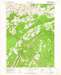
1963 Map of Donation
USGS Topo · Published 1964About this map
Standing Stone Creek and its tributary Shaver Creek carve through the parallel ridges of Huntingdon County in the early 1960s, defining a landscape of agricultural valleys and timbered heights. Small crossroads settlements like Cottage, Manor Hill, and Saulsburg serve the surrounding rural population, while industrial history is noted at Cornpropst Mills. The area shows a heavy emphasis on conservation and education, with large tracts dedicated to the Pennsylvania State University Experimental Forest and State Game Lands No 112. Local genealogy is well-supported by several distinct burial sites, including the Steel Cem and the Agundath Achim Memorial Park. Topographical landmarks like Round Top and the long spine of Standing Stone Ridge separate the various drainage basins, such as Gregory Run and Lick Run, which supported the early mills and farms of the region.
Find a feature on this map
53 named features on this map. Tap any name to fly to it.
Don’t see what you’re looking for? This feature index may not catch every label — zoom into the map to look around manually.
Map Details
Editions of this 1963 Donation Map
3 editions found
Other maps of this area

1901 · Huntingdon
USGS Topo · 1:62,500

1904 · Huntingdon
USGS Topo · 1:62,500

1919 · Menno
USGS Topo · 1:62,500

1922 · Mt Union
USGS Topo · 1:48,000

1923 · Tyrone
USGS Topo · 1:62,500

1924 · Mt. Union
USGS Topo · 1:62,500

1929 · Tyrone
USGS Topo · 1:48,000

1933 · Tyrone
USGS Topo · 1:62,500

1935 · Allensville
USGS Topo · 1:62,500

1938 · Allensville
USGS Topo · 1:62,500