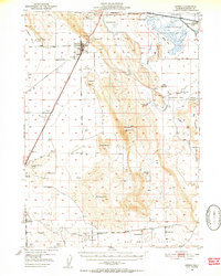
1950 Map of Dorris
USGS Topo · Published 1952About this map
Butte Valley dominates this 1950s landscape, serving as a high-altitude agricultural and transportation corridor just south of the California Oregon Approximate Boundary Line. The town of Dorris sits at the northern gateway, characterized by its position along the Southern Pacific railroad and the Pacific Highway. The presence of a Plant Quarantine Sta at the border reflects the importance of regulating agricultural movement between states during this era.
Find a feature on this map
44 named features on this map. Tap any name to fly to it.
Don’t see what you’re looking for? This feature index may not catch every label — zoom into the map to look around manually.
Map Details
Editions of this 1950 Dorris Map
4 editions found

Other maps of this area

1886 · Modoc Lava Bed
USGS Topo · 1:250,000

1886 · Shasta
USGS Topo · 1:250,000

1889 · Klamath
USGS Topo · 1:250,000

1891 · Ashland
USGS Topo · 1:250,000

1892 · Modoc Lava-Bed
USGS Topo · 1:250,000

1893 · Ashland
USGS Topo · 1:250,000

1894 · Klamath
USGS Topo · 1:250,000

1894 · Shasta
USGS Topo · 1:250,000

1897 · Ashland
USGS Topo · 1:250,000

1934 · Macdoel
USGS Topo · 1:96,000