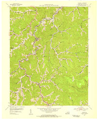
1954 Map of Dorton
USGS Topo · Published 1955About this map
Virgie and Dorton anchor this mid-century look at the coal and rail corridors of Pike County, where the Chesapeake and Ohio railroad snakes through the steep valleys of Shelby Creek. This area's social fabric is densely mapped through its many neighborhood institutions, including the Community Hospital and a high concentration of rural schools like Robinson Sch and Booker Fork Sch. The map reveals a landscape deeply connected by its watercourses, from Greasy Creek to the Rockhouse Fork, and the narrow hollows that housed family homesteads and local churches like Jones Chapel and Pilgrims Rest Ch. High above the creek-bottom settlements, the Flatwood Lookout Tower stands as a sentinel over the wooded ridges. The inclusion of numerous mines and oil wells speaks to the industrial character of the mountains during the early 1950s.
Find a feature on this map
95 named features on this map. Tap any name to fly to it.
Don’t see what you’re looking for? This feature index may not catch every label — zoom into the map to look around manually.
Map Details
Editions of this 1954 Dorton Map
3 editions found
Other maps of this area

1886 · Grundy
USGS Topo · 1:125,000

1890 · Whitesburg
USGS Topo · 1:125,000

1890 · Grundy
USGS Topo · 1:125,000

1892 · Grundy
USGS Topo · 1:125,000

1892 · Whitesburg
USGS Topo · 1:125,000

1912 · Pound
USGS Topo · 1:48,000

1913 · Clintwood
USGS Topo · 1:62,500

1914 · Pound
USGS Topo · 1:62,500

1914 · Vergie
USGS Topo · 1:48,000

1915 · Clintwood
USGS Topo · 1:62,500