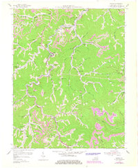
1954 Map of Dorton
USGS Topo · Published 1978About this map
Shelby Creek defines the central axis of this landscape, its winding course mirrored by the Chesapeake and Ohio RR as it connects coal-country settlements in the mid-1950s. The region’s economic life is visible in the network of strip mines and industrial structures like the Tipple and Conveyor near Esco Sch. These industrial features are balanced by a dense social fabric of local education and faith, evidenced by the many small schools such as Lower Caney Sch and Bear Fork Sch, and community landmarks like Jones Chapel and the Community Hospital. From the larger village of Virgie to the southern reaches of Dorton, the map illustrates a topography where every major branch—including Long Fork and Caney Creek—served as a vital corridor for family homes and community life. Local history is deeply embedded in the hollows, from Bratten Hol to Roberts Hol, where the valley floors were the primary sites for growth.
Find a feature on this map
72 named features on this map. Tap any name to fly to it.
Don’t see what you’re looking for? This feature index may not catch every label — zoom into the map to look around manually.
Map Details
Editions of this 1954 Dorton Map
3 editions found
Other maps of this area

1886 · Grundy
USGS Topo · 1:125,000

1890 · Whitesburg
USGS Topo · 1:125,000

1890 · Grundy
USGS Topo · 1:125,000

1892 · Grundy
USGS Topo · 1:125,000

1892 · Whitesburg
USGS Topo · 1:125,000

1912 · Pound
USGS Topo · 1:48,000

1913 · Clintwood
USGS Topo · 1:62,500

1914 · Pound
USGS Topo · 1:62,500

1914 · Vergie
USGS Topo · 1:48,000

1915 · Clintwood
USGS Topo · 1:62,500